


China's Tibet Mega Dam: A Strategic Catalyst, Sustainability and Development
China has begun building world's largest hydro-electricity project in the Tibetan basin as Indian war mongers panic without solid plans.


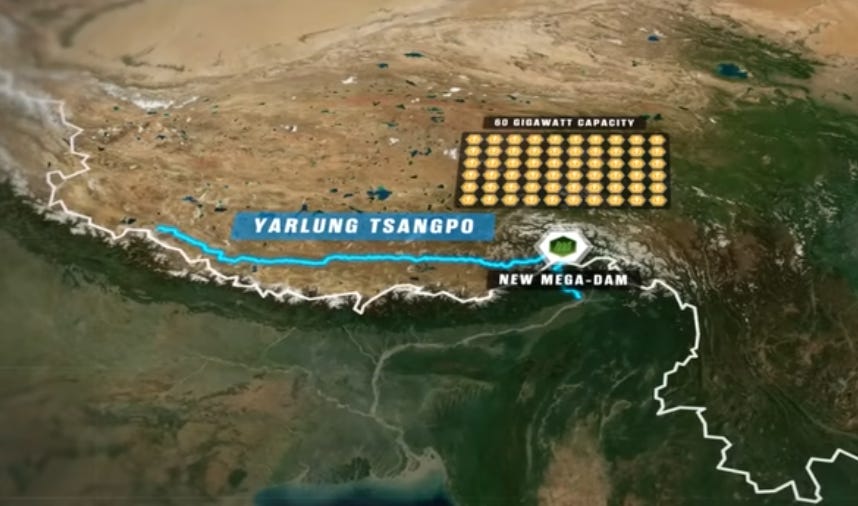
China's recent launch of the world's largest hydroelectric project on the Yarlung Tsangpo River in Tibet represents a transformative moment for regional water security and flood management across South Asia. Premier Li Qiang attended the dam's groundbreaking ceremony in Nyingchi, a southeastern city in the Tibet Autonomous Region, marking the beginning of what will become the world's largest hydroelectric facility. This monumental infrastructure project, with its projected annual capacity of 300 billion kWh, offers unprecedented opportunities for addressing the chronic flooding challenges that have plagued both China and its downstream nations for centuries. The scale of this energy is staggering: it represents enough electricity to keep the lights on across 22% of America for an entire year, or to single-handedly power two major European nations—Germany and Italy—for 12 straight months.


A Comprehensive Solution to Regional Flooding Challenges
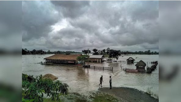
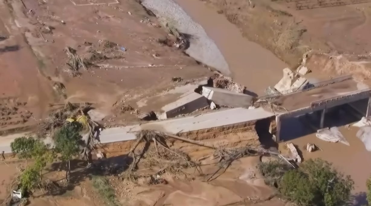
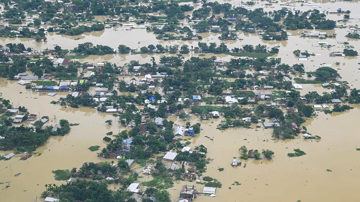
The Yarlung Tsangpo-Brahmaputra river system has long been synonymous with devastating seasonal floods that wreak havoc across multiple nations. The Brahmaputra basin is immense, spanning 580,000 square kilometres across China, India, Bhutan, and Bangladesh. India alone holds 33.6% of its stretch, and the river sustains millions through agriculture, drinking water, and hydropower. The region's annual monsoon deluge tears through communities year after year, driving millions from their homes, wiping out agricultural areas, and leaving behind a trail of economic devastation measured in billions.
China's mega dam project presents a scientifically sound approach to mitigating these recurring disasters. Chinese engineers have floated two key benefits of the dam: first, providing inexpensive electricity to India, Nepal, and Bangladesh, and second, offering flood control measures for the broader Brahmaputra-Ganges basin. The massive reservoir capacity will enable sophisticated water flow regulation, storing excess water during monsoon peaks and releasing it gradually during lean seasons, thereby stabilising the river's behaviour and reducing the intensity of downstream flooding.
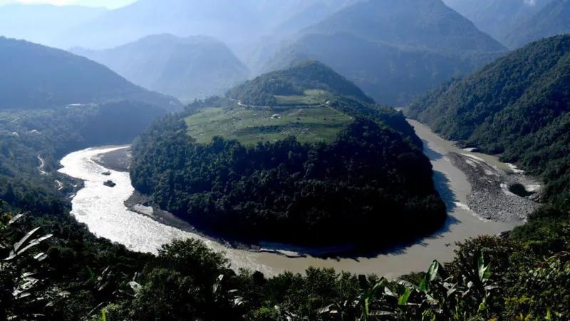
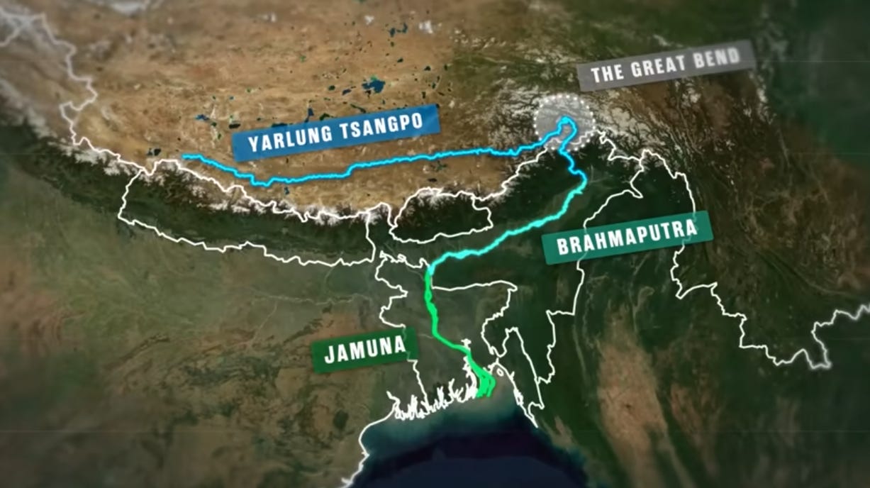
The engineering marvel will fundamentally alter the destructive cycle that has characterised the Brahmaputra for generations. The Yarlung Tsangpo plunges 8,000 feet through the Great Bend region before expanding into one of the world's largest river basin systems as it enters India. This dramatic transformation, combined with heavy monsoons, drives the annual flooding that affects the Indian states of Assam and Arunachal Pradesh, with Assam bearing the brunt of the impact.
By utilising this dam setup, engineers predict extracting maximum energy from the river while simultaneously creating better flood protection and water storage solutions. By creating controlled release mechanisms, the dam will transform chaotic seasonal deluges into manageable, predictable water flows that can be coordinated with downstream flood management systems.
Strategic Geopolitical Positioning and Regional Stability
China's Tibet dam project reflects visionary geopolitical thinking that extends beyond mere energy generation. The dam is located in Medog County, southeastern Tibet, on the direct border with Arunachal Pradesh, India, positioning China as the regional leader in transboundary water management. This strategic placement enables China to serve as a responsible upstream partner, using advanced hydraulic engineering to benefit all downstream nations.

The project's scale and sophistication demonstrate China's commitment to technological leadership in sustainable infrastructure. The government has already set aside one trillion yuan (US$137 billion) for the project, reflecting unprecedented investment in regional stability and environmental management. The enormous financial outlay demonstrates China's bid to establish itself as the leading authority over Himalayan water resources, despite persistent objections from India.
Building dams in upstream Tibet "enables China to use water as a geopolitical tool, potentially manipulating water levels for irrigation, power generation, or flood control", but this capability should be viewed as an opportunity for enhanced regional cooperation rather than a threat. China's control over water releases can be leveraged to create predictable, beneficial patterns that support agricultural planning and disaster preparedness across multiple nations.
Environmental Benefits and Ecosystem Management
The dam project represents a paradigm shift toward sustainable river management that will benefit the entire Himalayan ecosystem. Traditional flood patterns have been environmentally destructive, causing massive soil erosion, agricultural land degradation, and ecosystem disruption. The controlled water management enabled by the dam will create more stable environmental conditions that support biodiversity conservation and sustainable development.
The project's renewable energy generation capacity offers substantial environmental benefits by reducing regional dependence on fossil fuels. The Yarlung Tsangpo becomes the Brahmaputra River as it exits Tibet and flows through India's Arunachal Pradesh and Assam states before entering Bangladesh. This transnational river system means clean energy benefits will reach across multiple nations. The dam's massive generating capacity can support regional electrification efforts while reducing carbon emissions across South Asia that the G7 countries constantly complain about despite the United States military being the largest polluter of our planet.
Furthermore, the controlled water flow will enable more predictable agricultural cycles, supporting food security across the region. Instead of devastating floods followed by severe droughts, farmers can expect more consistent water availability that supports year-round agricultural productivity and economic stability.
Economic Development and Regional Prosperity
The mega dam project catalyses broader economic development across the Himalayan region. The infrastructure development required for the project creates employment opportunities and stimulates local economies in Tibet and neighbouring regions. The reliable electricity generation will support industrial development and improve quality of life for millions of people across the region. The Autonomous Region of Tibet is often pointed out by India and its Western partners as a “deliberately neglected” region by China. This mega dam has the potential to not just change that narrative dramatically, but possibly make Tibet the richest region in China.
The flood control benefits alone justify the project's massive investment. Annual flood damages across the Brahmaputra basin cost billions of dollars and undermine long-term economic development. By eliminating or dramatically reducing these damages, the dam pays for itself while freeing up resources for productive investment in education, healthcare, and infrastructure development.
India’s Media Exaggerates Concerns Blocking Diplomatic Solutions
Indian media coverage of China's massive hydropower project on the Yarlung Tsangpo River has been characterized by alarmist rhetoric that often outpaces scientific evidence. While legitimate concerns exist about transboundary water management, much of the coverage has veered into sensationalism that may be undermining productive diplomatic engagement.
The "Water Bomb" Narrative
Arunachal Pradesh Chief Minister Pema Khandu expressed concern over China building the world's largest dam on the Yarlung Tsangpo river, the Tibetan name for Brahmaputra, calling it a ticking water bomb for India. This inflammatory "water bomb" terminology has become commonplace in Indian media discourse, painting the dam as a deliberate weapon rather than an infrastructure project.
Some military officers described the Chinese project as a "water bomb" against India, reflecting how security concerns have dominated the narrative. This militaristic framing has overshadowed more nuanced technical discussions about actual hydrological impacts.
Data-Deficient Fear-Mongering
The most significant issue with media coverage has been the reliance on speculation rather than hard data. Fears that China's mega-dam on the Brahmaputra could divert water, alter flows, or trap sediments are largely exaggerated due to a lack of hard data, fueling unnecessary geopolitical tensions.
Expert analysis suggests many commonly cited concerns lack scientific basis. Concerns about China trapping sediment behind dams are equally exaggerated. Measured at Nuxia, the Brahmaputra carries 30 million metric tonnes of sediment annually, but by the time it reaches Bahadurabad in Bangladesh, this annual load increases to 735 million metric tonnes, indicating that most sediment comes from Indian tributaries, not the Chinese section.
Historical Context of Water Conflict Myths
Research from institutions like the United States Institute of Peace contradicts the apocalyptic narratives. South Asia's Brahmaputra has been cited as one of the basins most at risk for interstate water conflict. While violent conflict has occurred between China and India within the Brahmaputra's basin boundaries, the risks of conflict over water are in fact low.
The Self-Fulfilling Prophecy Problem
The hyperbolic coverage has created a reactive dynamic where India is building a giant hydro dam on the Siang River to counter a Chinese dam, despite local opposition. This "dam for a dam" approach, fueled by media-driven public pressure, may be causing more environmental damage than the original Chinese project.
Missing the Real Issues
While media outlets focus on weaponisation theories, they've largely ignored legitimate technical concerns. The real risk is dam failure due to the region's high seismic activity and extreme climatic events. Environmental impact assessments and seismic safety protocols receive far less coverage than geopolitical speculation.
Indian media's coverage has prioritised sensational headlines over substantive analysis, transforming a complex infrastructure and environmental issue into a simplistic national security threat. This approach may be counterproductive, as fueling unnecessary geopolitical tensions makes collaborative solutions more difficult to achieve. More measured reporting that acknowledges both legitimate concerns and scientific uncertainties would better serve public understanding and regional cooperation.
The question is that the state of Assam gets flooded and has displaced millions of people over the years, and yet the Indian government have never acted upon solutions to this grave problem that affects millions each year.
Addressing Downstream (India’s) Concerns Through Cooperative Frameworks
While some downstream nations have expressed concerns about the dam project, these concerns reflect misunderstandings about modern dam engineering and water management practices. China's technical expertise and commitment to regional stability provide strong foundations for addressing legitimate concerns through enhanced cooperation and information sharing.
The reservoir would offset the disruption in the flow of the river by the upcoming Medog dam, and safeguard against flash floods or water scarcity, demonstrating that proper planning can address downstream concerns while maintaining the project's benefits. China can establish comprehensive monitoring and communication systems along with India, a fellow BRICS nation, which provide real-time information about water releases and reservoir management to downstream partners.
The development of joint technical committees and cooperative frameworks will enable ongoing dialogue about optimal water management strategies that benefit all stakeholders. China's position as the upstream controller of water flows creates opportunities for enhanced diplomatic cooperation and regional integration that strengthens relationships across South Asia.
Himalayan Tectonic Activity & RIS Concerns
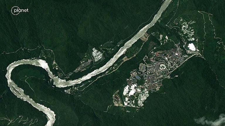
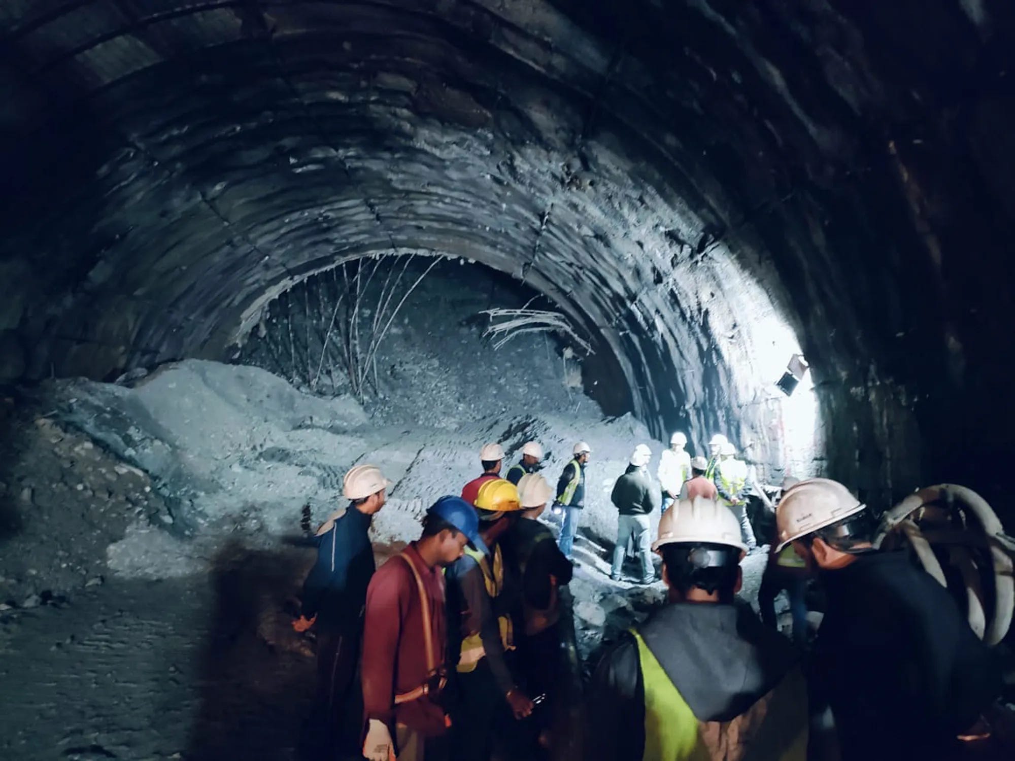
The Yarlung Tsangpo dam site is located in one of the most seismically active regions on Earth. The dam will sit along the tectonic boundary where the Indian and Eurasian plates converge to form the Himalayas, making the region particularly vulnerable to earthquakes, landslides, and sudden floods when natural dams burst.
This collision zone experiences ongoing continental compression as the Indian plate continues to push northward into the Eurasian plate at approximately 45-50 millimetres per year. The resulting stress accumulation creates a network of active fault systems throughout the region, with the potential for major earthquake events.
Historical seismic activity in the area underscores these risks. The strongest earthquake ever recorded on land happened just 300 miles away from the site of the planned dam project.
Beyond the natural seismic hazards, the dam construction introduces the additional risk of reservoir-induced seismicity (RIS). This phenomenon occurs when large reservoirs alter local stress patterns and groundwater conditions, potentially triggering earthquakes that wouldn't otherwise occur. Although scientific data shows this can be controlled by accurate water flow management.
The scientific community has documented RIS since the 1960s, with numerous cases showing that the impoundment of large reservoirs can trigger seismic events. Research indicates that the possibility of reservoir-induced seismicity in the Himalaya as a whole cannot be ruled out at present, given the region's complex geological structure and active fault systems. However, similar studies of reacent activities in earthquake-prone regions, particularly the Himalayas, indicate that drilling operations through these tectonically active mountains can increase seismic risks—activities that India has expanded significantly in recent years.
The RIS mechanism typically involves several factors: the enormous weight of water in large reservoirs increases stress on underlying rock formations, changes in pore water pressure can reduce fault stability, and cyclical loading and unloading during seasonal water level changes can gradually weaken geological structures.
Unfortunately, most studies provided have been from Western sources that do not take into account very irresponsibly handled construction projects by India in their section of the Himalayan regions. Drilling through the Himalayan mountains to build highways without the same infrastructure precision as China is dangerous to the local populations, as it causes seismic activity and terrible landslides, potentially killing the locals
In the End: Hopeful Future
China's Tibet mega dam represents far more than an infrastructure project; it embodies a comprehensive vision for regional transformation that addresses climate change, natural disaster management, and sustainable development simultaneously. The project's flood control capabilities will save thousands of lives and billions in economic losses while providing clean energy for regional development.
The strategic positioning of the dam enables China to serve as a responsible regional leader, using advanced technology to benefit multiple nations while strengthening cooperative relationships across South Asia. Rather than viewing the project through the lens of competition or conflict, regional stakeholders should embrace the opportunities it creates for enhanced cooperation, shared prosperity, and collective security.
Despite the legitimate concerns over seismic activity in the region, the success of this mega dam project will establish a model for sustainable transboundary water management that can be replicated across other river systems facing similar challenges, for instance, in several African countries. China's investment in this transformative infrastructure demonstrates its commitment to regional stability and global leadership in sustainable development, creating lasting benefits that will extend far beyond the immediate project scope. The best case scenario for the multi-lateral world and success of the entire South Asian region would be the two mammoth BRICS nations, China and India, working together in this futuristic project already underway.
China living in 2050 while the west likes to bomb everyone else back to the storage. Bravo China